 Cox's Bazar (Bengali: কক্সবাজার)
is a town, a fishing port and district headquarters in Bangladesh. It
is known for its wide sandy beach which is the world's longest natural
sandy sea beach. It is an unbroken 125 km sandy sea beach with a
gentle slope. It is located 150 km south of Chittagong. Cox’s Bazar is
also known by the name "Panowa", the literal translation of which
means "yellow flower". Its other old name was "Palongkee". The modern
Cox's Bazar derives its name from Captain Cox (died 1799), an officer
serving in British India. In the 18th century, an officer of British
East India Company, Captain
Hiram Cox was appointed as the Superintendent of Palongkee outpost after Warren Hastings became
the Governor of Bengal. Captain Cox was specially mobilised to deal
with a century long conflict between Arakan refugees and local
Rakhains. The Captain was a compassionate soul and the plight of the
people touched his heart. He embarked upon the mammoth task of
rehabilitating refugees in the area, and made significant progress. A
premature death took Captain Cox in 1799 before he could finish his
work. But the work he had done earned him a place in the hearts of the
locals and to commemorate his role in rehabilitation work a market
was established and named after him as Cox's Bazaar ("Cox's Market").
Although Cox's Bazar is one of the most visited tourist destinations
in Bangladesh, it has yet to become a major international tourist
destination, due to lack of publicity.
Cox's Bazar (Bengali: কক্সবাজার)
is a town, a fishing port and district headquarters in Bangladesh. It
is known for its wide sandy beach which is the world's longest natural
sandy sea beach. It is an unbroken 125 km sandy sea beach with a
gentle slope. It is located 150 km south of Chittagong. Cox’s Bazar is
also known by the name "Panowa", the literal translation of which
means "yellow flower". Its other old name was "Palongkee". The modern
Cox's Bazar derives its name from Captain Cox (died 1799), an officer
serving in British India. In the 18th century, an officer of British
East India Company, Captain
Hiram Cox was appointed as the Superintendent of Palongkee outpost after Warren Hastings became
the Governor of Bengal. Captain Cox was specially mobilised to deal
with a century long conflict between Arakan refugees and local
Rakhains. The Captain was a compassionate soul and the plight of the
people touched his heart. He embarked upon the mammoth task of
rehabilitating refugees in the area, and made significant progress. A
premature death took Captain Cox in 1799 before he could finish his
work. But the work he had done earned him a place in the hearts of the
locals and to commemorate his role in rehabilitation work a market
was established and named after him as Cox's Bazaar ("Cox's Market").
Although Cox's Bazar is one of the most visited tourist destinations
in Bangladesh, it has yet to become a major international tourist
destination, due to lack of publicity.Friday, February 22, 2013
Cox's Bazar (Bengali: কক্সবাজার)
Cox's Bazar (Bengali: কক্সবাজার)
is a town, a fishing port and district headquarters in Bangladesh. It
is known for its wide sandy beach which is the world's longest natural
sandy sea beach. It is an unbroken 125 km sandy sea beach with a
gentle slope. It is located 150 km south of Chittagong. Cox’s Bazar is
also known by the name "Panowa", the literal translation of which
means "yellow flower". Its other old name was "Palongkee". The modern
Cox's Bazar derives its name from Captain Cox (died 1799), an officer
serving in British India. In the 18th century, an officer of British
East India Company, Captain
Hiram Cox was appointed as the Superintendent of Palongkee outpost after Warren Hastings became
the Governor of Bengal. Captain Cox was specially mobilised to deal
with a century long conflict between Arakan refugees and local
Rakhains. The Captain was a compassionate soul and the plight of the
people touched his heart. He embarked upon the mammoth task of
rehabilitating refugees in the area, and made significant progress. A
premature death took Captain Cox in 1799 before he could finish his
work. But the work he had done earned him a place in the hearts of the
locals and to commemorate his role in rehabilitation work a market
was established and named after him as Cox's Bazaar ("Cox's Market").
Although Cox's Bazar is one of the most visited tourist destinations
in Bangladesh, it has yet to become a major international tourist
destination, due to lack of publicity.Mughal Bridges of Dhaka
Postogola/Millbarrack is seen in the back
It can hardly be overemphasized that the conservation of our cultural past is very important to nourish our sense of identity, national pride and self-esteem. There is, therefore, an overwhelming need for creating a general consciousness among the people of the importance of conservation activities relating to our past heritage.
from the book of prof Muntasir Mamun
Partition of Bengal 1905 and its annulment in 1911..
Map of Province of East BengalAssam 1907


More Imege is old Bangladesh
Bengal, Bihar and Orissa had formed a single province of British India since 1765. After the British put down the Sepoy Rebellion of 1875, the government dissolved the East India Company and took direct control of the province. At this time, British control extended from Eastern Bengal across the entire Ganges plain, to the Indus valley, in distant north-western India with Calcutta as capital. The British officials also moved into the Chittagong Hills. Their the British officials governed the local hill peoples, who had remained independent in their remote corner of East Bengal.
The Lt. Governor of Bengal had to administer an area of 189,000 sq miles and by 1903 the population of the province rose to 78.50 million. Eastern part of Bengal, because of isolation and poor communications, had been neglected in favour of west Bengal and Bihar. In East Bengal, the countryside was cut off by rivers and creeks, and no attention had been paid till the last decade of the 19th century. The condition of peasants was miserable. Piracy in waterways existed for at least a century. Eastern Bengal was almost isolated from the western part, the region was thought to be neglected and under-governed. On the other hand Calcutta (Kolkata) and its nearby districts of west Bengal attracted all energy and attention of the administration.
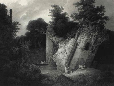
Mughal Edifices in ruins under British rule: 1757-1947
 Lalbagh Fort S-W Bastion (area now known as Qillar Mor)
built by prince Azam, 3rd son of Emperor Aurangzeb in 1678. The fort
was named Qilla Aurangbad: Sir Charles D'oyle's (Collector of Dhaka
since early 18th century) etching of 1816. Fort details click: "Lalbagh Fort Salvaged....
Lalbagh Fort S-W Bastion (area now known as Qillar Mor)
built by prince Azam, 3rd son of Emperor Aurangzeb in 1678. The fort
was named Qilla Aurangbad: Sir Charles D'oyle's (Collector of Dhaka
since early 18th century) etching of 1816. Fort details click: "Lalbagh Fort Salvaged....Lalbagh Fort south east gate - Photo 1870
1 la Baishakh Bangla (New year)
Cultural function
 The first day of the Bengali calendar year "Pahela Baishakh" is celebrated as the New Year in Bangladesh. The history of the Bengali New Year is not very old.
In Bengal, Emperor Akbar started the Bengali calendar year on 10 March 1585, but it became effective from 16 March 1586, the day of his ascension to the throne. The basis of the Bengali year is the Hegira [ Hijri ] lunar year (Muslim era counted from the year of prophet Muhammad's (SM) going to Medina in 622 AD). The Bengali year was accepted at the grass root level irrespective of religious differences. The Bengali New Year is in summer, not a pleasant time in Bangladesh. It was fixed due to practical necessities. A strong reason for the creation of Bengali year is agriculture and the beginning of the Bengali year is a time of collection of taxes from the farmers.
Saint Martins Island

Understand Saint Martins is a tropical cliché and the only coral island in the country, with beaches fringed with coconut palms and laid-back locals. It's a clean and peaceful place with nothing more strenuous to do than soak up the rays — even mosquitoes are a rarity. There's a naval base near the center of the island, and the USA looked into setting up one of their own a few years back. The island was devastated by a cyclone in 1991 but has fully recovered, and was untouched by the 2004 tsunami.
The Sixty Pillar Mosque (the Shat Gambuj)
 The Sixty Pillar Mosque (the Shat Gambuj), a mosque located in Bagerhat
in south Bangladesh, on the eastern bank of a sweet water tank or pond
is one of the oldest mosques in the country, and is described as
"historic mosque representing the Golden Era of Muslim Bengal". It is laid is over an area of 160 feet (49 m)x108 feet (33 m) size.
The mosque is unique in the sense thahttps://www.blogger.com/blogger.g?blogID=931499313351750286#editor/src=sidebart it has 60 pillars that support
77 exquisitely curved "low squat domes" that have worn away with the
passage of time; it has seven central domes that are four-sided and
built in Bengali style. It was used for prayers, as an assembly hall and madrasa
(an Islamic school). Seventy seven domes are over the roof and four
smaller ones at the four corners are towers (the towers were used to
call the faithfuls to attend prayers). The large prayer hall has 11
arched doorways on the east and 7 each on the north and south which
provide ventilation and light to the hall. There are also 7 longitudinal
aisles and 11 deep bays in the midst of slim columns made of stone.
These columns support the curving arches that are overlaid by the domes. The west wall in the interior has eleven mihrabs that are decorated with stonework and terracotta and the flooring is of brickwork. The walls and the mihrabs
were affected by sulphates. Most of the damages have been rectified. It
was established in 1440 by Khan Jahan Ali. The arches are 6 feet
(1.8 m) thick with a slight taper over the hollow and round walls. The
mosque also functioned as the court of Khan Jahan Ali. It now attracts a
large number of tourists and visitors every year. The mosque is
decorated mostly with terracotta and bricks
The Sixty Pillar Mosque (the Shat Gambuj), a mosque located in Bagerhat
in south Bangladesh, on the eastern bank of a sweet water tank or pond
is one of the oldest mosques in the country, and is described as
"historic mosque representing the Golden Era of Muslim Bengal". It is laid is over an area of 160 feet (49 m)x108 feet (33 m) size.
The mosque is unique in the sense thahttps://www.blogger.com/blogger.g?blogID=931499313351750286#editor/src=sidebart it has 60 pillars that support
77 exquisitely curved "low squat domes" that have worn away with the
passage of time; it has seven central domes that are four-sided and
built in Bengali style. It was used for prayers, as an assembly hall and madrasa
(an Islamic school). Seventy seven domes are over the roof and four
smaller ones at the four corners are towers (the towers were used to
call the faithfuls to attend prayers). The large prayer hall has 11
arched doorways on the east and 7 each on the north and south which
provide ventilation and light to the hall. There are also 7 longitudinal
aisles and 11 deep bays in the midst of slim columns made of stone.
These columns support the curving arches that are overlaid by the domes. The west wall in the interior has eleven mihrabs that are decorated with stonework and terracotta and the flooring is of brickwork. The walls and the mihrabs
were affected by sulphates. Most of the damages have been rectified. It
was established in 1440 by Khan Jahan Ali. The arches are 6 feet
(1.8 m) thick with a slight taper over the hollow and round walls. The
mosque also functioned as the court of Khan Jahan Ali. It now attracts a
large number of tourists and visitors every year. The mosque is
decorated mostly with terracotta and bricks
TEA GARDENS
 Sylhet, a land of two leaves and a bud, is surrounded by miles after
miles of tea gardens. A number of tea gardens around Sylhet town, among
them Lakkatura, Malnichara, Khadimnagor tea estates are the oldest and
densely cultivated tea plantation. You can enjoy driving or walking
through sandy road in the tea garden
Sylhet, a land of two leaves and a bud, is surrounded by miles after
miles of tea gardens. A number of tea gardens around Sylhet town, among
them Lakkatura, Malnichara, Khadimnagor tea estates are the oldest and
densely cultivated tea plantation. You can enjoy driving or walking
through sandy road in the tea garden Nuhas polli

Favorite Fiction Writer : Humayun Ahmed, who is buried in nuhas polli. you leaf herb planting, pulses Help fans. Hundreds of cars this garden has become the home of the carpet grass plowed field.
I buried apart from the rest of the rope dragging notice can not be maintained. The fans are the victim’s rights and nuhas hamlet worke
Lalon Shah's Mazar
 Lalon (Bengali: লালন) also Lalon Sain, Lalon Shah, Lalon Fakir or Mahatma Lalon Fakir; (c. 1774–1890), was a Bengali Baul saint, mystic, songwriter, social reformer and secular thinker. In Bengali culture
he has become an icon of religious tolerance and secularism whose songs
inspired and influenced many poets and social and religious thinkers
including Rabindranath Tagore, Kazi Nazrul Islam, and Allen Ginsberg - though, as he "rejected all distinctions of caste and creed", he was both praised and criticized in his lifetime and after his death. His disciples mostly live in Bangladesh and West Bengal. He founded the institute known as Lalon Akhdah in Cheuriya, about 2 km. from Kushtia railway station. He is also regarded as the founder of the Baul music.
Lalon (Bengali: লালন) also Lalon Sain, Lalon Shah, Lalon Fakir or Mahatma Lalon Fakir; (c. 1774–1890), was a Bengali Baul saint, mystic, songwriter, social reformer and secular thinker. In Bengali culture
he has become an icon of religious tolerance and secularism whose songs
inspired and influenced many poets and social and religious thinkers
including Rabindranath Tagore, Kazi Nazrul Islam, and Allen Ginsberg - though, as he "rejected all distinctions of caste and creed", he was both praised and criticized in his lifetime and after his death. His disciples mostly live in Bangladesh and West Bengal. He founded the institute known as Lalon Akhdah in Cheuriya, about 2 km. from Kushtia railway station. He is also regarded as the founder of the Baul music.Northbrook Hall (Lalkuthi)
Northbrook Hall (Lalkuthi) front view as seen from north in 19th century
View from south (Buriganga river side)

Northbrooke Hall, an elegant building popularly known as ‘Lalkuthi’ for its deep red colour, is situated at Farashganj, Dhaka on the north bank of the Buriganga River. It was originally built in late 19th century as a Town Hall and named after Lord Northbrooke, Viceroy of India (1872-1876). His administration was marked by agrarian unrest in Bengal.
Northbrooke Hall combines elements of Mughal architecture blended with architectural styles of the European Renaissance. The building's semi-circular horseshoe arches containing entrances on the north, the four octagonal minars with pinnacles and the ornamental parapet demonstrate the Muslim features. The deep red colour of the grand monument with its graded roofs, pinnacles and parapets presents a magnificent view from the riverfront.
The town hall was later converted into a public library, to which a clubhouse was added and called Johnson Hall.
The building, however, has lost its attraction now because of the new
structures, such as assembly halls and community centres that have been
built on the same premises and surround it from all sides. The
premises of the hall now offer facilities for social and cultural
gatherings. The library on the premises is a major reading centre for
the people of old Dhaka.
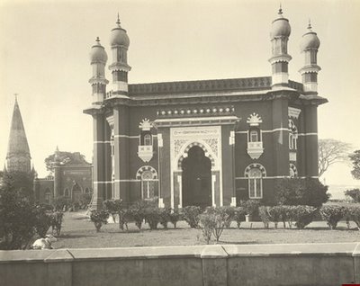
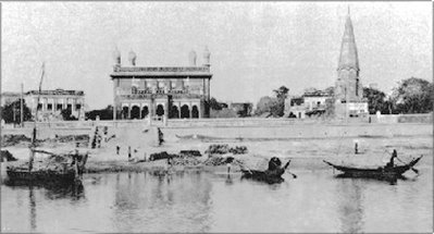
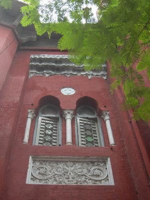
Star Mosque,(Bengali: তারা মসজিদ)
 Star Mosque (Bengali: তারা মসজিদ; also known as Tara Masjid), is a mosque located in Armanitola area, Dhaka, Bangladesh. The mosque has ornate designs and is decorated with motifs of blue stars. It was built in the first half of the 19th century by Mirza Golam Pir (Mirza Ahmed Jan).
A very beautiful mosque of the city is situated at Mahuttuly on Abul Khairat Rd; just west of Armanitola Govt. High School. Architecturally faultless (Mughal style) is a five-dome mosque with hundreds of big and small twinkling stars as surface decorations.The stars have been created by setting pieces of chinaware on white cement. Seen from the front and from far it looks as if shining above the surface of the earth. The inside of it is even more beautiful that the outside, lovely mosaic floor and excellent tiles with many floral patterns set on the walls, are all in complete harmony.
Sonadia Island
 Sonadia is a crescent shaped island off the Cox's Bazar coast. The
area of the island is about 9 sq km. Its western coast is sandy and is
rich in different kinds of shells. At the northern part of the island,
there are beds of windowpane oysters.
Sonadia is a crescent shaped island off the Cox's Bazar coast. The
area of the island is about 9 sq km. Its western coast is sandy and is
rich in different kinds of shells. At the northern part of the island,
there are beds of windowpane oysters. The history of human habitation of Sonadia Island is no more than 100-125 years. The island is divided into two neighborhoods or Para- East and West neighborhood. There live at around 2000 people in Sonadia Dwip. Most of the people live in Eastern side. Main occupations of the Islander are catching fish, collection of shrimp and other minnow etc.During winter, fishermen set up temporary camps on the island and dry sea fishes, which they catch from the sea. Every winter thousands of fishermen camp there and make large hauls.
Madhabkunda Waterfall
 Madhabkunda (Bengali: মাধবকুন্ড) is the
largest waterfall in Bangladesh situated in Barlekha thana
(subdistrict) in Moulvi Bazar District, Sylhet Division. The waterfall
is one of the most attractive tourist spots in Bangladesh. Lots of
tourists and picnic parties come to Madhabkunda every day for their
enjoyment. Fall of million tons of water form 200 ft. height. Big
bolder of stones and the black stones with green leafy trees and the
sound of waterfall is giving a shape of care in Madhabkunda.
Madhabkunda (Bengali: মাধবকুন্ড) is the
largest waterfall in Bangladesh situated in Barlekha thana
(subdistrict) in Moulvi Bazar District, Sylhet Division. The waterfall
is one of the most attractive tourist spots in Bangladesh. Lots of
tourists and picnic parties come to Madhabkunda every day for their
enjoyment. Fall of million tons of water form 200 ft. height. Big
bolder of stones and the black stones with green leafy trees and the
sound of waterfall is giving a shape of care in Madhabkunda.Geography and Distance It is Located at 24°38′21″N 92°13′16″E and about 200 ft (61 m) high. It is about five km away from Dakshinbagh railway station on the Kulaura-Shabajpur track (see Akhaura-Kulaura-Chhatak Line), and 350 km from Dhaka city.
Mahasthangarh (Bengali: মহাস্থানগড় )
 Mahasthangarh
is the oldest archaeological site in Bangladesh. It dates back to 700
BCE and was the ancient capital of the Pundra Kingdom.
Mahasthangarh
is the oldest archaeological site in Bangladesh. It dates back to 700
BCE and was the ancient capital of the Pundra Kingdom.Mahasthangarh (Bengali: মহাস্থানগড় Môhasthangôṛ) is the earliest urban archaeological site so far discovered in Bangladesh. The village Mahasthan in Shibganj thana of Bogra District contains the remains of an ancient city which was called Pundranagara or Paundravardhanapura in the territory of Pundravardhana. A limestone slab bearing six lines in Prakrit in Brahmi script, discovered in 1931, dates Mahasthangarh to at least the 3rd century BC. The fortified area was in use till the 18th century AD.
Jaflong
 Jaflong
is one of the most attractive tourist spots in Sylhet division. It's
about 60 km far from Sylhet town and takes two hours drive to reach
there. Jaflong is also a scenic spot nearby amidst tea gardens and rate
beauty of rolling stones from hills. It is situated besides the river
Mari in the lap of Hill Khashia.The Mari river is coming from the
great Himalayas of India, which bringing million tons of stone
boulders with its tide. You can watch the stone collection from the
river in Jaflong as well as you can enjoy the boating in the river
Mari. Jaflong is totally a hilly area of real natural beauty where
hills are greenish with the forests.Lots of wild animal lives in this
forest, so you need to be careful to enter in the forest alone. You
can see the lifestyle of Tribe Khashia in Jaflong. If you intend to
visit Jaflong it is
advisable to start from Sylhet in the early morning
so that you can comeback by evening covering the other tourists spots
of nearby areas of Jaflong. The other tourist areas nearby Jaflong are
Tamabil, Sripur and Jaintapur.
Jaflong
is one of the most attractive tourist spots in Sylhet division. It's
about 60 km far from Sylhet town and takes two hours drive to reach
there. Jaflong is also a scenic spot nearby amidst tea gardens and rate
beauty of rolling stones from hills. It is situated besides the river
Mari in the lap of Hill Khashia.The Mari river is coming from the
great Himalayas of India, which bringing million tons of stone
boulders with its tide. You can watch the stone collection from the
river in Jaflong as well as you can enjoy the boating in the river
Mari. Jaflong is totally a hilly area of real natural beauty where
hills are greenish with the forests.Lots of wild animal lives in this
forest, so you need to be careful to enter in the forest alone. You
can see the lifestyle of Tribe Khashia in Jaflong. If you intend to
visit Jaflong it is
advisable to start from Sylhet in the early morning
so that you can comeback by evening covering the other tourists spots
of nearby areas of Jaflong. The other tourist areas nearby Jaflong are
Tamabil, Sripur and Jaintapur.Nillgiri hill resort

The
world Nilgiri hill at Bandarban, where the top hotel of Gentle breeze
was blowing down the hill side and thin clouds were hanging around on
their way to casual fly. Dimmed through the clouds, silver moon light
was rolling down the folds and slopes. Getting out of the cottage
Moheshkhali Island
 Moheshkhali
Island is another attraction for the tourists who go to Cox’s
Bazaar. An island off the coast of Cox’s Bazar. It has an area of 268
square kilometers. Through the center of the island and along the
eastern coastline rises, a range of low hills, 300 feet high; but the
coast to the west and north is a low-lying treat, fringed by
mangrove jungle. In the hills on the coast is built the shrine of
Adinath, dedicated to Siva. By its side on the same hill is Buddhist
Pagoda. You can go to this Island by local motorboat called trawler
or by speedboat. By trawler, it takes an hour and a half and by
speedboat, it takes only half an hour to reach this Island. You will
find mangrove forests,
Moheshkhali
Island is another attraction for the tourists who go to Cox’s
Bazaar. An island off the coast of Cox’s Bazar. It has an area of 268
square kilometers. Through the center of the island and along the
eastern coastline rises, a range of low hills, 300 feet high; but the
coast to the west and north is a low-lying treat, fringed by
mangrove jungle. In the hills on the coast is built the shrine of
Adinath, dedicated to Siva. By its side on the same hill is Buddhist
Pagoda. You can go to this Island by local motorboat called trawler
or by speedboat. By trawler, it takes an hour and a half and by
speedboat, it takes only half an hour to reach this Island. You will
find mangrove forests,  hilly
areas, salt field etc. This island is famous for Buddhist Temple and
Pagoda; you can enjoy a full day sight seeing if you intend to visit
Sonadia and some other Islands nearby. In the morning you can start
for Moheskhali, spend time to watch Moheskhali’s tourist places, take
lunch there and on return you can visit Sonadia and other nearby
Islands where you can sea the live fishing & fishermen lifestyle;
By the afternoon you can come back to Cox’s Bazaar
hilly
areas, salt field etc. This island is famous for Buddhist Temple and
Pagoda; you can enjoy a full day sight seeing if you intend to visit
Sonadia and some other Islands nearby. In the morning you can start
for Moheskhali, spend time to watch Moheskhali’s tourist places, take
lunch there and on return you can visit Sonadia and other nearby
Islands where you can sea the live fishing & fishermen lifestyle;
By the afternoon you can come back to Cox’s Bazaar Kuakata (Bengali: কুয়াকাটা)
 Kuakata (Bengali: কুয়াকাটা)
is a panaromic sea beach on the southernmost tip of Bangladesh .Located
in the Patuakhali district, Kuakata has a wide sandy beach from where
one can see both the sunrise and sunset. It is about 320 Kilometres
south of Dhaka, the capital, and about 70 Kilometres from the district
headquarters. The Kuakata beach is 30 km long and 6 km wide. On 13
September 2007 government had announced a red alert in Kuakata as
caution for a possible Tsunami.
Kuakata (Bengali: কুয়াকাটা)
is a panaromic sea beach on the southernmost tip of Bangladesh .Located
in the Patuakhali district, Kuakata has a wide sandy beach from where
one can see both the sunrise and sunset. It is about 320 Kilometres
south of Dhaka, the capital, and about 70 Kilometres from the district
headquarters. The Kuakata beach is 30 km long and 6 km wide. On 13
September 2007 government had announced a red alert in Kuakata as
caution for a possible Tsunami.Rajbon Bihar Ragamati

It is 1 km far from Moitri Vihar situated at Rangamati municipality. Rajbon Bihar is one of the lovely Buddhist temple of Bangladesh. It is Located at rangamati district. It is one of the well-known tourist place of Rangamati just few km. from the main bus terminal. You can hire a boat or a auto-rickswa to visit the Bihar. It is a Pindapata temple. About 50 to 70 monks reside here regularly. Visitor are requested to keep in mind thist it is a place of prayer, so do not do anything that hart any one by you.
You must have to enter that place with bare feet to respect their tradition. In rajbon Bihr, there are many monkey stay around the Place. You can give them some food/nuts. There is a 7 stored building and wit a name each floor represents a paradise. Entering into the main prayer area, There are some small buildings/prayer hall inside.A musk of Buddha Prepared from bronze and kept with a wall for the tourist inside the Bihar. No matter from where you are looking at that musk, you'll feel that its looking at you. There is an eldest monk, named "Ven Sadhanananda Mahathero (Bana Bante)", who is around 94 years of old, and lots of Buddhist used to visit with tribute to get Please from him, and the god. From all directions it is a beautiful tourist spot. So you are welcome in this site to visit
Patenga (Bengali: পতেঙ্গা)

Patenga is a popular tourist spot. The beach is very close to Bangladesh Naval Academy of Bangladesh Navy, and Shah Amanat International Airport. The beach width is narrow and swimming in the seas is not recommended. Part of the seashore is built-up with concrete walls. Also large blocks of stones have been laid out to prevent erosion. During 1990s a host of restaurants and kiosks have sprouted out around the beach area. Lighting of the beach area has enhanced the security aspect of visiting in the night. People rise up early in the morning to witness the beautiful sunrise.Many visitors to Bangladesh find Chittagong to be the perfect tourist destination. It is filled with dense green forests, endless rolling hills, a moderate climate and breathtaking beaches. Since the seventh century, Chittagong has been mentioned in many documents as a seaport of mystical beauty and magnificent charm. The bustling harbor stands in stark contrast to the tranquility and peaceful surroundings of the city. And attractions, such as Patenga Beach, ensure a constant influx of travelers and visitors.
Some old Sketches and Pics of Dhaka City

Foy's Lake

| This article needs additional citations for verification. Please help improve this article by adding citations to reliable sources. Unsourced material may be challenged and removed. (October 2011) |
Nijhum Dwip(Bengali: নিঝুম দ্বীপ)
 Nijhum Dwip
means, Silent Island (Bengali: নিঝুম দ্বীপ) is a small island under
Hatiya upazila. It is situated in Noakhali District in Bangladesh. Once
it was called as Char Osman
Nijhum Dwip
means, Silent Island (Bengali: নিঝুম দ্বীপ) is a small island under
Hatiya upazila. It is situated in Noakhali District in Bangladesh. Once
it was called as Char OsmanHistory
It was not settled until 1970, until then only seaonally. At the time it was called Nijhum Dwip (the quiet island) was included in the Hatiya constituency after permanent settlement. Then because of riverbank erosion in nearby areas, especially Hatiya, Shahbajpur and Ramgati people migrated to the island as new settlers.Population
The population in Nijhum Dwip in 2001 was 10,670. Their main occupations are cultivation, fishing and livestock farming. The island produces vegetables. But the island suffers from natural calamities, and life is hard and risky.Current status
Nijhum Dwip presently has six big bazaars with mainly the grocery shops, small restaurants and drug stores. These bazaars are the only places in the islands to have electricity from generators. The forest department of the government of Bangladesh created mangrove forests in Nijhum Dwip and the main attraction in these forests is the herd of about 5000 spotted dear. The most important type of tree planted in the island is Keora, also known as Kerfa, which has fast growing roots holding the sandy land. The plant also supplies pillars for houses, materials for making boats and agricultural implements, and fuel for domestic use. In 2001, the government of Bangladesh declared Nijhum Dwip forests as National Park.The Sundarbans
 Home of the Royal Bengal Tigers In the south western part of
Bangladesh, in the district of greater Khulna, lies the Sundarbans,
"the beautiful forest." It is a virgin forest which until recently
owed nothing to human endeavour and yet nature has laid it out with as
much care as a planned pleasure ground. For miles and miles, the
lofty treetops form an unbroken canopy, while nearer the ground, works
of high and ebb-tide marked on the soil and tree trunks and the many
varieties of the natural mangrove forest have much to offer to an
inquisitive visitor. Here land and water meet in many novel fashions.
Wild life presents many a spectacle. No wonder, you may come across a
Royal Bengal Tiger swimming across the streams or the crocodiles
basking on the river banks. With the approach of the evening herds of
deer make for the darking gladeswhere boisterous monkeys shower Keora
leaves from above for sumptuous meal for the former. For the botanist,
the lover of nature, the poet and the painter this land provides a
variety of wonders for which they all crave.The Sundarbans is a cluster of islands with an approximate area of 3600
sq. km. forming the largest block of littoral forests. It's beauty
lies in its unique natural surrounding. Thousands of meandering streams,
creeks, rivers and estuaries have enhanced its charm. Sundarbans
meaning beautiful forest is the natural habitat of the world famous
Royal Bengal Tiger, spotted deer, crocodiles, jungle fowl, wild boar,
lizards, rhesus monkey and an innumerable variety of beautiful birds.
Migratory flock of siberian ducks flying over thousands of sail boats
loaded with timber, gopatta (round-leaf), fuel wood, honey, shell and
fish further add to the serene natural beauty of the Sundarbans.
Home of the Royal Bengal Tigers In the south western part of
Bangladesh, in the district of greater Khulna, lies the Sundarbans,
"the beautiful forest." It is a virgin forest which until recently
owed nothing to human endeavour and yet nature has laid it out with as
much care as a planned pleasure ground. For miles and miles, the
lofty treetops form an unbroken canopy, while nearer the ground, works
of high and ebb-tide marked on the soil and tree trunks and the many
varieties of the natural mangrove forest have much to offer to an
inquisitive visitor. Here land and water meet in many novel fashions.
Wild life presents many a spectacle. No wonder, you may come across a
Royal Bengal Tiger swimming across the streams or the crocodiles
basking on the river banks. With the approach of the evening herds of
deer make for the darking gladeswhere boisterous monkeys shower Keora
leaves from above for sumptuous meal for the former. For the botanist,
the lover of nature, the poet and the painter this land provides a
variety of wonders for which they all crave.The Sundarbans is a cluster of islands with an approximate area of 3600
sq. km. forming the largest block of littoral forests. It's beauty
lies in its unique natural surrounding. Thousands of meandering streams,
creeks, rivers and estuaries have enhanced its charm. Sundarbans
meaning beautiful forest is the natural habitat of the world famous
Royal Bengal Tiger, spotted deer, crocodiles, jungle fowl, wild boar,
lizards, rhesus monkey and an innumerable variety of beautiful birds.
Migratory flock of siberian ducks flying over thousands of sail boats
loaded with timber, gopatta (round-leaf), fuel wood, honey, shell and
fish further add to the serene natural beauty of the Sundarbans.Rakhain
 Rakhain, The a small tribe of arakan origin belonging to the
Bhotbarmi community of the Mongoloids. Many consider that Rakhains and
their neighbours, marmas are in fact, the same tribe. The skull of
Rakhains is round, their nose is flat, they have black hair, they are
usually short in height, and their complexion is light brown. A
section of Rakhains started living in ramu and its adjacent areas in
chittagong hill tracts in the fifteenth century. In the eighteenth
century, many Rakhain people migrated from their homeland in Arakan
because of political turmoil and they gradually settled in different
areas of Chittagong Hill Tracts and patuakhali. There were 4,049
Rakhains in the Patuakhali region in 1872. The number increased to
16,394 in 1951, but reduced to 3,713 in 1979. The census of 1991
recorded the number of Rakhain population in Bangladesh at about
7,000. More than eighty per cent of them lived in Ramu, cox’s bazar,
Bandarban, Manikchhari and Teknaf. Though Buddhists by religious
faith, Rakhains, like other tribes and sub-tribes,
believe in superstitions, magic and supernatural powers. They lead
very simple lives. The birth anniversary of Gautam buddha is one of
their major religious ceremonies. They observe the spring festival and
the Baishakhi, maghi purnima and prabarana purnima. ‘Sundrey’ is
their greatest community festival and is observed for three days on
the occasion of Chaitra Sankranti.Everybody takes part in this
festival. Young boys and girls sing songs and perform dances in
groups. The main profession of Rakhains is farming. They also weave and
make salt and molasses. Both males and females take part in
agricultural work. But women take the leading role in livestock rearing
and poultry. Some Rakhains are involved in business and a few of them
teach. Their diet includes rice, fish, pulses and vegetables. Pork
and dried fish are favourite foods. They serve decorated pithas
(cakes) and sweet rice porridge on ceremonial occasion. The common
dress of Rakhain men is the lungi and fatua while the women wear
embroidered lungis and blouses and also various types of ornaments on
their bodies and flowers on their heads. Marriage is a religious and
social obligation in Rakhain society. Generally marriages are arranged
by guardians, but nowadays, love marriages are also recognised. dowry
is not accepted among Rakhains. Though the father is the formal head
of the family, both male and female members have equal rights. Sons
and daughters inherit parental property in equal proportion. The
language of Rakhains belongs to the Bhotbarmi group of languages.
Rakhain children start their education at Buddhist Patshalas (primary
school) or khyangs (monastery). They receive both religious and
linguistic education there. The rate of literacy in the Rakhain
community is very high and some of them are highly educated. Rakhains
burn the bodies after death and bury the remains. The shraddha ceremony
for the dead person is held after seven days from death.
Rakhain, The a small tribe of arakan origin belonging to the
Bhotbarmi community of the Mongoloids. Many consider that Rakhains and
their neighbours, marmas are in fact, the same tribe. The skull of
Rakhains is round, their nose is flat, they have black hair, they are
usually short in height, and their complexion is light brown. A
section of Rakhains started living in ramu and its adjacent areas in
chittagong hill tracts in the fifteenth century. In the eighteenth
century, many Rakhain people migrated from their homeland in Arakan
because of political turmoil and they gradually settled in different
areas of Chittagong Hill Tracts and patuakhali. There were 4,049
Rakhains in the Patuakhali region in 1872. The number increased to
16,394 in 1951, but reduced to 3,713 in 1979. The census of 1991
recorded the number of Rakhain population in Bangladesh at about
7,000. More than eighty per cent of them lived in Ramu, cox’s bazar,
Bandarban, Manikchhari and Teknaf. Though Buddhists by religious
faith, Rakhains, like other tribes and sub-tribes,
believe in superstitions, magic and supernatural powers. They lead
very simple lives. The birth anniversary of Gautam buddha is one of
their major religious ceremonies. They observe the spring festival and
the Baishakhi, maghi purnima and prabarana purnima. ‘Sundrey’ is
their greatest community festival and is observed for three days on
the occasion of Chaitra Sankranti.Everybody takes part in this
festival. Young boys and girls sing songs and perform dances in
groups. The main profession of Rakhains is farming. They also weave and
make salt and molasses. Both males and females take part in
agricultural work. But women take the leading role in livestock rearing
and poultry. Some Rakhains are involved in business and a few of them
teach. Their diet includes rice, fish, pulses and vegetables. Pork
and dried fish are favourite foods. They serve decorated pithas
(cakes) and sweet rice porridge on ceremonial occasion. The common
dress of Rakhain men is the lungi and fatua while the women wear
embroidered lungis and blouses and also various types of ornaments on
their bodies and flowers on their heads. Marriage is a religious and
social obligation in Rakhain society. Generally marriages are arranged
by guardians, but nowadays, love marriages are also recognised. dowry
is not accepted among Rakhains. Though the father is the formal head
of the family, both male and female members have equal rights. Sons
and daughters inherit parental property in equal proportion. The
language of Rakhains belongs to the Bhotbarmi group of languages.
Rakhain children start their education at Buddhist Patshalas (primary
school) or khyangs (monastery). They receive both religious and
linguistic education there. The rate of literacy in the Rakhain
community is very high and some of them are highly educated. Rakhains
burn the bodies after death and bury the remains. The shraddha ceremony
for the dead person is held after seven days from death.
Rangamati(Bengali: রাঙ্গামাটি)
 This article may contain wording that merely promotes the subject without imparting verifiable information. Please remove or replace such wording, unless you can cite independent sources that support the characterization. Rangamati(Bengali:
রাঙ্গামাটি) is the Administrative Headquarter of Rangamati Hill
District in the Chittagong Hill Tracts of Bangladesh. The town is
located at 22°37'60N 92°12'0E and has an altitude of 14 metres
(49 feet).
This article may contain wording that merely promotes the subject without imparting verifiable information. Please remove or replace such wording, unless you can cite independent sources that support the characterization. Rangamati(Bengali:
রাঙ্গামাটি) is the Administrative Headquarter of Rangamati Hill
District in the Chittagong Hill Tracts of Bangladesh. The town is
located at 22°37'60N 92°12'0E and has an altitude of 14 metres
(49 feet).Jatiyo Sangshad Bhaban (Parliament House)
Louis Kahn designed the entire Jatiyo Sangsad complex, which includes lawns, lake and residences for the Members of the Parliament (MPs).
 Location and basic layout
The enclave, situated in Sher-e-Bangla Nagar, is bounded by four major streets:1. Lake Road to the North;
2. Rokeya Sarani to the East;
3. Manik Mia Avenue to the South; and
4. Mirpur Road to the West.
The main building (the Bhaban) is divided into three parts:
1. The Main Plaza: 823,000 square feet (76,000 m²)
2. South Plaza: 223,000 square feet (21,000 m²)
3. Presidential Plaza: 65,000 square feet (6,000 m²)
Sonargaon (Bengali: সোনারগাঁও)
 Sonargaon (Bengali: সোনারগাঁও; also transcribed as Sunārgāon)
was the administrative center of medieval Muslim rulers in East
Bengal. It became as the capital of Bengal during Isa Khan's ruling.
The area falls under present-day Narayanganj District, Bangladesh.
Today the name Sonargaon survives as Sonargaon Upazila in that district.
Sonargaon (Bengali: সোনারগাঁও; also transcribed as Sunārgāon)
was the administrative center of medieval Muslim rulers in East
Bengal. It became as the capital of Bengal during Isa Khan's ruling.
The area falls under present-day Narayanganj District, Bangladesh.
Today the name Sonargaon survives as Sonargaon Upazila in that district.History
Pre-Muslim periodThe name Sonargaon came as the Muslim version of the ancient name Suvarnagrama. Hindu ruler Danujamadhava Dasharathadeva shifted his capital to Suvarnagrama from Bikrampur sometime in the middle of the 13th century. In early 14th century, Hindu ruling in this area ended when Shamsuddin Firoz Shah (reigned 1301–1322) of Lakhnauti occupied and annexed it to his kingdom.
Muslim period
Muslim settlers first arrive in Sonargaon region in around 1281. Sharfuddin Abu Tawwamah, a medieval Sufi saint and Islamic philosopher came and settled here sometime between 1282 and 1287. He then established his Khanqah and founded a Madrasa.
Firoz Shah built a mint in Sonargaon from where a large number of coins were issued. When he died in 1322, his son, Ghiyasuddin Bahadur Shah, replaced him as the ruler. In 1324 Delhi Sultan, Ghiyasuddin Tughlaq, declared war against him and after the battle, Bahadur Shah was captured and Bengal, including Sonargaon, became a province of Delhi Sultanate. The same year, Sultan Muhammad bin Tughlaq, son and successor of Ghiyasuddin Tughlaq, released him and appointed him as the governor of Sonargaon province.
After 4 years of governorship, in 1328, Bahadur Shah declared independence of Bengal. Delhi Sultan Muhammad bin Tughlaq sent his general, Bahram Khan, to depose him. In the battle, Bahadur Shah was defeated and killed. Bahram Khan recaptured Sonargaon for the Delhi Sultanate and he was also appointed the governor of Sonargaon.
When Bahram Khan died in 1338, his armor-bearer, Fakhruddin Mubarak Shah, declared himself the independent Sultan of Sonargaon. Fakhruddin sponsored several construction projects, including a trunk road and raised embankments, along with mosques and tombs. 14th century Moroccan traveller, Ibn Batuta, after visiting the capital in 1346, described Fakhruddin as "a distinguished sovereign who loved strangers, particularly the fakirs and sufis". After the death of Fakhruddin in 1349, Ikhtiyaruddin Ghazi Shah became the next independent ruler of Sonargaon.
Ilyas Shah, the independent ruler of Lakhnauti, attacked Sonargaon in 1352. After defeating Ikhtiyaruddin Ghazi Shah, he became the sole ruler of whole Bengal for the first time in history and thus he became the founder of a sultanate of the unified Bengal.
It is thought that when a squadron of the Chinese fleet of Zheng He, commanded by the eunuch Hong Bao, visited Bengal in 1432, they visited Sonargaon as well. The information about that expedition comes from the book of one of its participants, the translator Ma Huan.
Sonargaon is the eastern terminus of the Grand Trunk Road, which was built by the Pashtun emperor Sher Shah Suri, extended approximately 2500 kilometres from Bangladesh across northern India and Pakistan to Kabul in Afghanistan.
Isa Khan's ruling
When Taj Khan Karrani was the independent Afghan ruler of Bengal, Isa Khan obtained an estate in Sonargaon and Maheswardi Pargana in 1564 as a vassal of the Karrani rulers. Isa Khan gradually increased his strength and in 1571 he was designated as the ruler of whole Bhati region. In 1575 he helped Daud Khan Karrani to fight with Mughal flotilla in the vicinity of Sonargaon.Daud Khan Karrani died in the battle of Rajmahal against Mughals in 1576. Akbar then assigned Isa Khan as one of the Bara-Bhuiyans by making him the zamindar of Sonargaon. Since then he resisted Mughal's ruling in his area. With the help of allies, he stood defiant against Mughals in the battle against Subahdar Khan Jahan in 1578, Subahdar Shahbaz Khan in 1584 and Durjan Singh in 1597. Isa Khan died in September 1599. Then his son, Musa Khan, took control of Bhati region. But after the defeat of Musa Khan in 10 July 1610 by Islam Khan, the army general of Mughals, Sonargaon became one of the sarkars of Bengal subah. The capital of Bengal is then shifted to Jahangirnagar (later named Dhaka).
Bangladesh period
On 15 February 1984, Narayanganj subdivision is upgraded to a district by the Government of Bangladesh. Hence Sonargaon became a subdistrict of Narayanganj District of Dhaka division.Trade
By the 14th century Sonargaon became a commercial port. Trade activities were mentioned by travelers like Ibn Batuta, Ma Huan and Ralph Fitch. Maritime ships travelled between Sonargaon and southeast/west Asian countries. Muslin was produced in this region.
Remains
Panam City
Lok Shilpa Jadughar (Folk Arts Museum) in Sonargaon.
- Panam City was established in the late 19th century as a trading center of cotton fabrics during British rule. Hindu cloth merchants built their residential houses following colonial style with inspiration derived from European sources. After the Indo-Pakistani War of 1965 and the Muslim-Hindu riot, Panam City has reduced into a vacant community. Today this area is protected under the department of archaeology of Bangladesh. Panam city area was linked with the main city area by three brick bridges - Panam Bridge, Dalalpur Bridge and PanamNagar Bridge - during Mughal period. The bridges are still in use.
- Lok Shilpa Jadughar (Folk Art and Craft Museum) of Sonargaon was established by Bangladeshi painter Joynul Abedin on March 12, 1975. The house, originally called Bara Sardar Bari, was built in 1901.
- Sonakanda Fort is a Mughal river-fort located on the bank of the Shitalakshya River at Bandar.
- Khasnagar Dighi, a lake in Khasnagar village.
Ahsan Manzil (Bengali: আহসান মঞ্জিল)
 Ahsan Manzil
(Bengali: আহসান মঞ্জিল) was the official residential palace and seat
of the Dhaka Nawab Family. This magnificent building is situated at
Kumartoli along the banks of the Buriganga River in Bangladesh. The
construction of this palace was started in the year 1859 and was
completed in 1869. It is constructed in the Indo-Saracenic Revival
architecture. To preserve the cultural and history of the area, the
palace became the Bangladesh National Museum on 20 September
1992.Contents
Ahsan Manzil
(Bengali: আহসান মঞ্জিল) was the official residential palace and seat
of the Dhaka Nawab Family. This magnificent building is situated at
Kumartoli along the banks of the Buriganga River in Bangladesh. The
construction of this palace was started in the year 1859 and was
completed in 1869. It is constructed in the Indo-Saracenic Revival
architecture. To preserve the cultural and history of the area, the
palace became the Bangladesh National Museum on 20 September
1992.ContentsBandarban Khagrasari Hilltrac,Bengali: বান্দরবান
 Bandarban is one of the most beautiful travel place in south Asia.Bandarban (Bengali: বান্দরবান)
is a district in South-Eastern Bangladesh, and a part of the
Chittagong Division and Chittagong Hill Tracts. Bandarban (meaning the dam of monkeys),
or in Marma or Arakanese language as "Rwa-daw Mro" is also known as
Arvumi or the Bohmong Circle of the rest of the three hill districts
Rangamati is the Chakma Circle and Khagrachari is the Mong Circle .
Bandarban town is the home town of the Bohmong Chief (currently King, or
Raja, Aung Shwe Prue Chowdhury who is the head of the Marma
population. It also is the administrative headquarter of Bandarban
district, which has turned into one of the most exotic tourist
attractions in Bangladesh since the insurgency in Chittagong Hill Tracts
has ceased more than a decade back.
Bandarban is one of the most beautiful travel place in south Asia.Bandarban (Bengali: বান্দরবান)
is a district in South-Eastern Bangladesh, and a part of the
Chittagong Division and Chittagong Hill Tracts. Bandarban (meaning the dam of monkeys),
or in Marma or Arakanese language as "Rwa-daw Mro" is also known as
Arvumi or the Bohmong Circle of the rest of the three hill districts
Rangamati is the Chakma Circle and Khagrachari is the Mong Circle .
Bandarban town is the home town of the Bohmong Chief (currently King, or
Raja, Aung Shwe Prue Chowdhury who is the head of the Marma
population. It also is the administrative headquarter of Bandarban
district, which has turned into one of the most exotic tourist
attractions in Bangladesh since the insurgency in Chittagong Hill Tracts
has ceased more than a decade back.Bandarban Travels

Asia : South Asia : Bangladesh : Chittagong Division : Bandarban
Bandarban Hill District
is the most remote and least populated district in Bangladesh. The
lure of the tallest peaks of Bangladesh, treks through virgin forests
and chance to meet more than 15 tribes of the region up close is
growing both among Bangladeshis and tourists from other countries.
Since the insurgency ceased in the Chittagong Hill Tracts (a cluster
that includes all three hill districts of Bangladesh) it has opened up
for tourists more than a decade back, though some of the western
tourist guides may still describe the area as a major security risk Chakma

Lalbagh Fort (Bengali: লালবাগ দূর্গ)
 The Lalbagh Fort was developed by Shaista Khan. Lalbagh Fort
(Bengali: লালবাগ দূর্গ) (also known as "Fort Aurangabad") is an
incomplete Mughal palace fortress at the Buriganga River in the
southwestern part of Dhaka, Bangladesh. Construction was commenced in
1678 by Prince Muhammad Azam during his 15-month long vice-royalty of
Bengal, but before the work could complete, he was recalled by
Aurangzeb. His successor, Shaista Khan, did not complete the work,
though he stayed in Dhaka up to 1688. His daughter Iran Dukht nicknamed
Pari Bibi (Fairy Lady) died here in 1684 and this led him to
consider the fort to be ominous.
The Lalbagh Fort was developed by Shaista Khan. Lalbagh Fort
(Bengali: লালবাগ দূর্গ) (also known as "Fort Aurangabad") is an
incomplete Mughal palace fortress at the Buriganga River in the
southwestern part of Dhaka, Bangladesh. Construction was commenced in
1678 by Prince Muhammad Azam during his 15-month long vice-royalty of
Bengal, but before the work could complete, he was recalled by
Aurangzeb. His successor, Shaista Khan, did not complete the work,
though he stayed in Dhaka up to 1688. His daughter Iran Dukht nicknamed
Pari Bibi (Fairy Lady) died here in 1684 and this led him to
consider the fort to be ominous.Muktagacha Rajbari
 Muktagacha
Rajbari is one of the oldest zaminder houses in Bangladesh. It is
situated at Muktagacha thana in Mymensingh district. It is an extensive
palatial complex sprawling over at least 20 hectors of land. The whole
area is full of many ponds, temples, palaces and out buildings.
Muktagacha
Rajbari is one of the oldest zaminder houses in Bangladesh. It is
situated at Muktagacha thana in Mymensingh district. It is an extensive
palatial complex sprawling over at least 20 hectors of land. The whole
area is full of many ponds, temples, palaces and out buildings.Of themonly a part is now being protected by the Deptt. of Archaeology. The protected area is an east facing enclosed precinct studded with gateway, garden, reservoirs, residential
complexes, temples and several other ancillary buildings. The architecture of all the buildings simulate Indo-European neo-classic ethic.
They were built by different members of the Muktagacha zamindar family in different time. Some are still being used for different purposes. The protected part is called ‘Char Ana' locally. It may hardly be dated in the early 20th century A.D.
Time has left its mark on the structure and all the precious dιcor inside and outside the palace are in a poor condition because of lack of proper care.
Mainamati(Bengali: ময়নামতি Môenamoti
 Shalban Vihara Shalban Vihara War cemetery at Mainamati Mainamati (Bengali: ময়নামতি Môenamoti)
is located almost 8 miles from the town of Comilla, Bangladesh. It is
the home of one of the most important Buddhist archaeological sites in
the region. There are a number of Buddhist sites in this region,
dating approximately from 7th to 12th centuries CE. Comilla Cantonment
is located nearby and houses a beautiful colonial era cemetery.
Shalban Vihara Shalban Vihara War cemetery at Mainamati Mainamati (Bengali: ময়নামতি Môenamoti)
is located almost 8 miles from the town of Comilla, Bangladesh. It is
the home of one of the most important Buddhist archaeological sites in
the region. There are a number of Buddhist sites in this region,
dating approximately from 7th to 12th centuries CE. Comilla Cantonment
is located nearby and houses a beautiful colonial era cemetery.Mainamati is named for the Candra queen of the same name, mother of the Govindachandra.
Buddhist monuments See also: History of Bangladesh The centre piece of the Buddhist sites at Mainamati is the Shalban vihara, almost in the middle of the Mainamati-Lalmai hill range. It is clearly a Vihara, or an educational centre with residential facilities. It consists of 115 cells, built around a spacious courtyard with a cruciform temple in the centre, facing its only gateway complex to the north, resembling that of the Sompur Bihara.
Zia Uddyan (Chandrima Uddyan)
 Zia
Uddyan or Chandrima Uddyan is one of the finest park and resting
center for Dhaka City Dwellers. Zia Uddyan is located just opposite
back to the Parliament House of Bangladesh, and the opposite western
Corner of Bangladesh Military Museum and Bangabandhu Novo Theatre. One
of the major and great leaders of Bangladesh, Late President Ziaur
Rahman was buried there. You can see the Graveyard of Shaheed President
Ziaur Rahman while visiting this place. Many people also have known
this place as “Chandrima Uddyan (crescent lake)”. The grave chamber of
Ziaur Rahman is a nice place. It is well decorated. Another excellent
seeing sight is the lake of Zia Uddyan or Chandrima Uddyan.
Zia
Uddyan or Chandrima Uddyan is one of the finest park and resting
center for Dhaka City Dwellers. Zia Uddyan is located just opposite
back to the Parliament House of Bangladesh, and the opposite western
Corner of Bangladesh Military Museum and Bangabandhu Novo Theatre. One
of the major and great leaders of Bangladesh, Late President Ziaur
Rahman was buried there. You can see the Graveyard of Shaheed President
Ziaur Rahman while visiting this place. Many people also have known
this place as “Chandrima Uddyan (crescent lake)”. The grave chamber of
Ziaur Rahman is a nice place. It is well decorated. Another excellent
seeing sight is the lake of Zia Uddyan or Chandrima Uddyan.Bangladesh National Museum (Bengali: বাংলাদেশ জাতীয় যাদুঘর)
 The Bangladesh National Museum (Bengali: বাংলাদেশ জাতীয় যাদুঘর),
originally established on 20 March 1913, albeit under another name,
and formally inaugurated on 7 August 1913, was accorded the status of
the national museum of Bangladesh on 17 November 1983. It is located
Shahbag, Dhaka. The museum is well organized and displays have been
housed in several departments like department of ethnography and
decorative art, department of history and classical art, department of
natural history, and
The Bangladesh National Museum (Bengali: বাংলাদেশ জাতীয় যাদুঘর),
originally established on 20 March 1913, albeit under another name,
and formally inaugurated on 7 August 1913, was accorded the status of
the national museum of Bangladesh on 17 November 1983. It is located
Shahbag, Dhaka. The museum is well organized and displays have been
housed in several departments like department of ethnography and
decorative art, department of history and classical art, department of
natural history, and department of contemporary and world civilization. The museum also has a conservation laboratory
Patenga (Bengali: পতেঙ্গা)

Patenga (Bengali: পতেঙ্গা)
is a sea beach located 14 kilometres south of the port city of
Chittagong, Bangladesh. It is near the mouth of the Karnaphuli River.
Patenga is a popular tourist spot. The beach is very close to Bangladesh Naval Academy of Bangladesh Navy, and Shah Amanat International Airport. The beach width is narrow and swimming in the seas is not recommended. Part of the seashore is built-up with concrete walls. Also large blocks of stones have been laid out to prevent erosion. During 1990s a host of restaurants and kiosks have sprouted out around the beach area. Lighting of the beach area has enhanced the security aspect of visiting in the night. People rise up early in the morning to witness the beautiful sunrise.Many visitors to Bangladesh find Chittagong to be the perfect tourist destination. It is filled with dense green forests, endless rolling hills, a moderate climate and breathtaking beaches. Since the seventh century, Chittagong has been mentioned in many documents as a seaport of mystical beauty and magnificent charm. The bustling harbor stands in stark contrast to the tranquility and peaceful surroundings of the city. And attractions, such as Patenga Beach, ensure a constant influx of travelers and visitors.
Patenga Beach lies approximately twenty kilometers outside the city of Chittagong, and is located near to fascinating landmarks including the Shah Amanat International Airport and the BNS Isha Khan Naval Base. It is located at the Karnaphuli River mouth and stretches to the Bay of Bengal. Vendors from the city flock to Patenga Beach to sell their selection of ice creams, cold drinks and food to the hundreds of tourists who come to Patenga Beach.
The beach itself is quite sandy, with a few rocky patches here and there. Most visitors come to Patenga Beach as it is known for having some of the most stunning sunsets and sunrises in Bangladesh. The more adventurous travelers will also be able to enjoy a river cruise on the Karnaphuli River, or a boat trip onto the ocean waves. Nature enthusiasts will find Patenga Beach to be a haven for most of the wading bird species of Bangladesh and if lucky, bird watchers will also be able to see spoon-billed sandpipers running around.
If the crowds at Patenga Beach become too much, visitors should move on to Parky Beach, which is just a quieter extension of Patenga. Here, the beach is lined with massive shady palm trees and fishing boats. Fishermen sit around peacefully, going about their daily chores while sea gulls patiently circle overhead waiting for the odd scrap of fish to be thrown their way. It is the perfect location for a quiet picnic or day of relaxation.
Visitors will find Patenga Beach to be diverse, fascinating and, above all, beautiful. It is a tourist destination that lures visitors with the attractions of good weather, natural splendor and the quiet lapping of the ocean waves at their feet. Every moment at Patenga Beach is a photographic opportunity and an unforgettable memory in the making.
Subscribe to:
Posts (Atom)